
Sample Tour · Published blueprint · Every booking tailored
Sample Tours. Tailored Trips. Your Pace. What follows is our first published blueprint: real roads, verified numbers, actual hotels. No departure we run is ever a copy of this page. Your Stage Racer tour is tailored to your individual requirements — every stage ridden at your pace.
The distances, climbs and profiles on this page come from our own pipeline: road routing through the exact towns and roads we scout, elevation sampled from terrain data at roughly 100 m spacing. Every stage is a day you own — ride the full profile, take the shortened route, or let the support vehicle carry you over any section on the day.
One more rule the page obeys: every ride ends before midday. The afternoons belong to the island.
- 12 days · 11 nights
- 8 stages
- 908 km riding
- +10,573 m climbing
- High point 1,461 m
- 9 roll-outs incl. acclimatisation
- Thema Collection hotels
- Operated by Connaissance de Ceylan
Day 1 · Arrive Colombo → Kandy
No stage profile — no legs required today.
You land at Colombo (CMB or BIM) and your chauffeur from Connaissance de Ceylan runs the transfer up to the hill capital in time for a mid-morning arrival at Mountbatten. Bikes are unboxed and built this afternoon; if you are renting instead of flying with boxes, the fit happens here too. Then a round of golf at the Victoria Golf and Country Resort — a leg-loosener with a view — and the day ends with drinks and dinner at the resort.
Day 2 · Acclimatisation ride: 50–70 km around Kandy
Guided loop of the Kandy hills · coffee stops · support vehicle shadowing.
06:30 roll-out for the first turn of the legs. Fifty to seventy kilometres, decided on the morning by how the group wakes up and how the jet lag votes. Easy gears, nothing pinned. Afternoon: Kandy town — the Temple of the Tooth, the lake, the market — before the tour proper starts tomorrow.
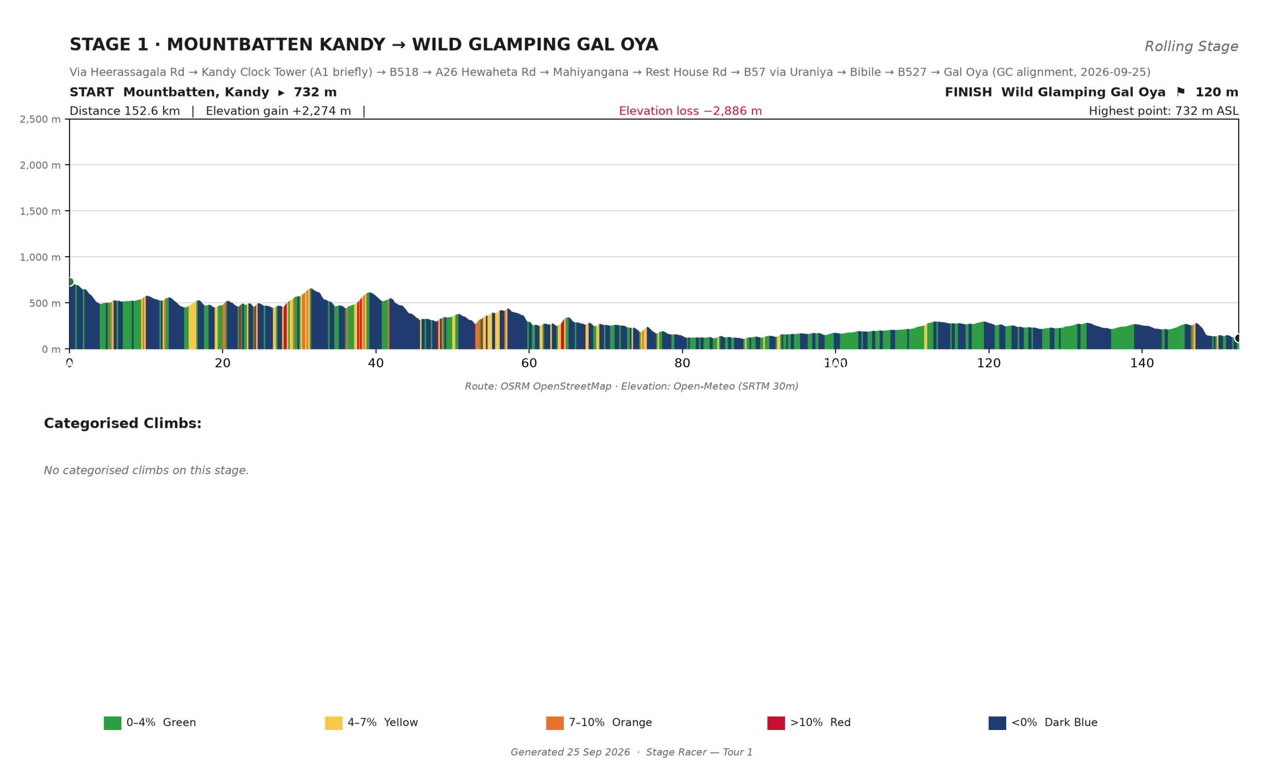
Day 3 · Stage 1: Mountbatten Kandy → Wild Glamping Gal Oya
Via Heerassagala Rd · A26 · B57 through Uraniya and Bibile · B527 to the tank
- 152.6 km
- +2,274 m
- −2,886 m
- 732 m → 120 m
- ~5 h 30–6 h moving
- No categorised climbs
The tour’s longest day is mostly downhill with good manners. You leave Mountbatten at 732 m in cool tea-estate air and finish 612 m lower on the Gal Oya shore — the fixed-axis profile below makes that release obvious at a glance. The work is front-loaded: the day’s biggest rise crests just past km 31. East of the Mahaweli the road settles into long, fast rollers, big-gear territory, as the thermometer climbs through the dry zone. No categorised climb all day; an 06:00 start puts you lakeside before the heat peaks.
At your pace: the full route suits most club riders. A shortened opener is possible at the Uraniya turn near km 84 — still 84 km of the best road of the day behind you — or the van takes the back half.
Afternoon: the tank-side camp at Wild Glamping. This is elephant country; they are regulars around the water. A Gal Oya boat safari can be added (see Add-Ons).
 Click to enlarge
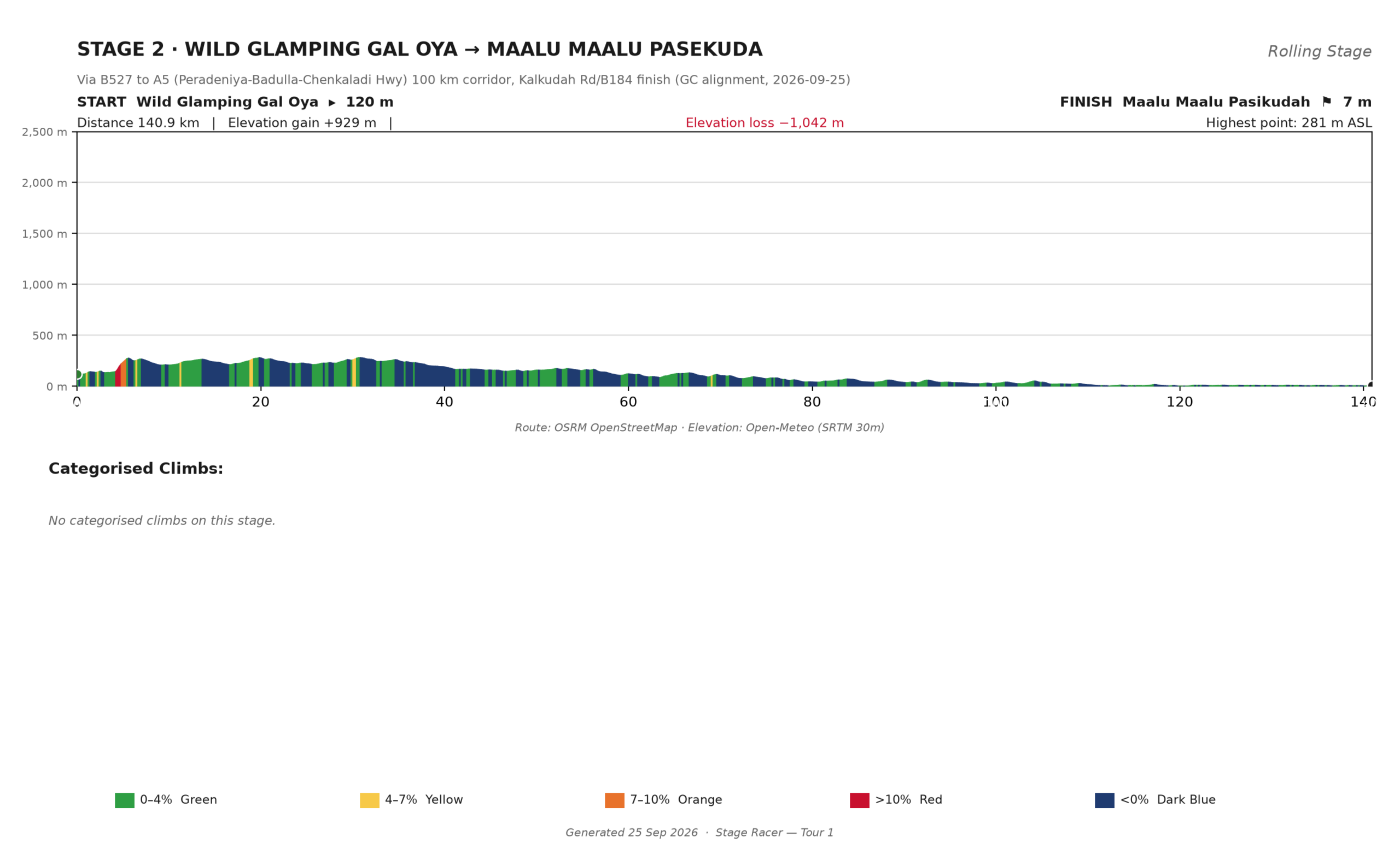
Day 4 · Stage 2: Wild Glamping Gal Oya → Maalu Maalu, Pasikudah
Via B527 Inginiyagala Rd · A5 Peradeniya–Badulla–Chenkaladi Hwy · B184 to Kalkudah
- 140.9 km
- +929 m
- −1,042 m
- 120 m → 7 m
- ~5 h moving
- No categorised climbs
One hill, then the ocean. The day’s only real work is the first 7 km out of the Gal Oya valley; from the plateau high point near km 30 it is a 110 km gentle fall to sea level. Most of it rides the A5, Sri Lanka’s longest road: two lanes of empty bitumen and long sight-lines. Hold one steady power on the rollers instead of chasing each one, and expect crosswinds once the trees thin east of km 90. 06:00 out, poolside before noon.
At your pace: a rhythm day. There is no climbing decision to make after km 30, so every group can ride it its own way and still share the finish.
Afternoon: Pasikudah’s reef-sheltered shallows at Maalu Maalu — the first proper ocean of the tour, and the warmest bath you will take this week.
 Click to enlarge
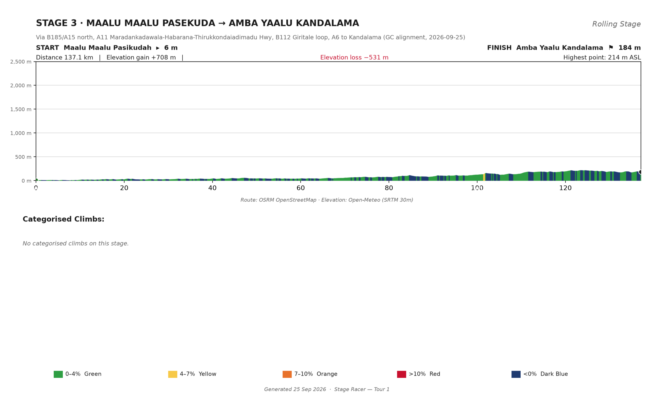
Day 5 · Stage 3: Maalu Maalu Pasikudah → Amba Yaalu Kandalama
Via B185/A15 north · A11 · B112 through Giritale · A6 to Kandalama
- 137.1 km
- +708 m
- −531 m
- 6 m → 184 m
- ~4 h 50 moving
- No categorised climbs
The only stage that starts at the sea and finishes on high ground. The first 70 km are exposed dry-zone tank plains — near-flat, near-shadeless — so the early start is non-negotiable and the bottle stops at the Giritale and Habarana cluster near km 83–100 are load-bearing. From km 75 the land lifts in long shallow steps: the last 35 km are a steady 2% ramp to the Kandalama shelf. Nothing earns a category, and legs still feel it.
At your pace: ride the flats at conversation pace and bank something for the escarpment; the van holds anything you need carried.
Afternoon: the Amba Yaalu terraces look straight down the Kandalama tank — the best sunset room in the network. Sigiriya Lion Rock is a short drive for the afternoon (see Add-Ons).
 Click to enlarge
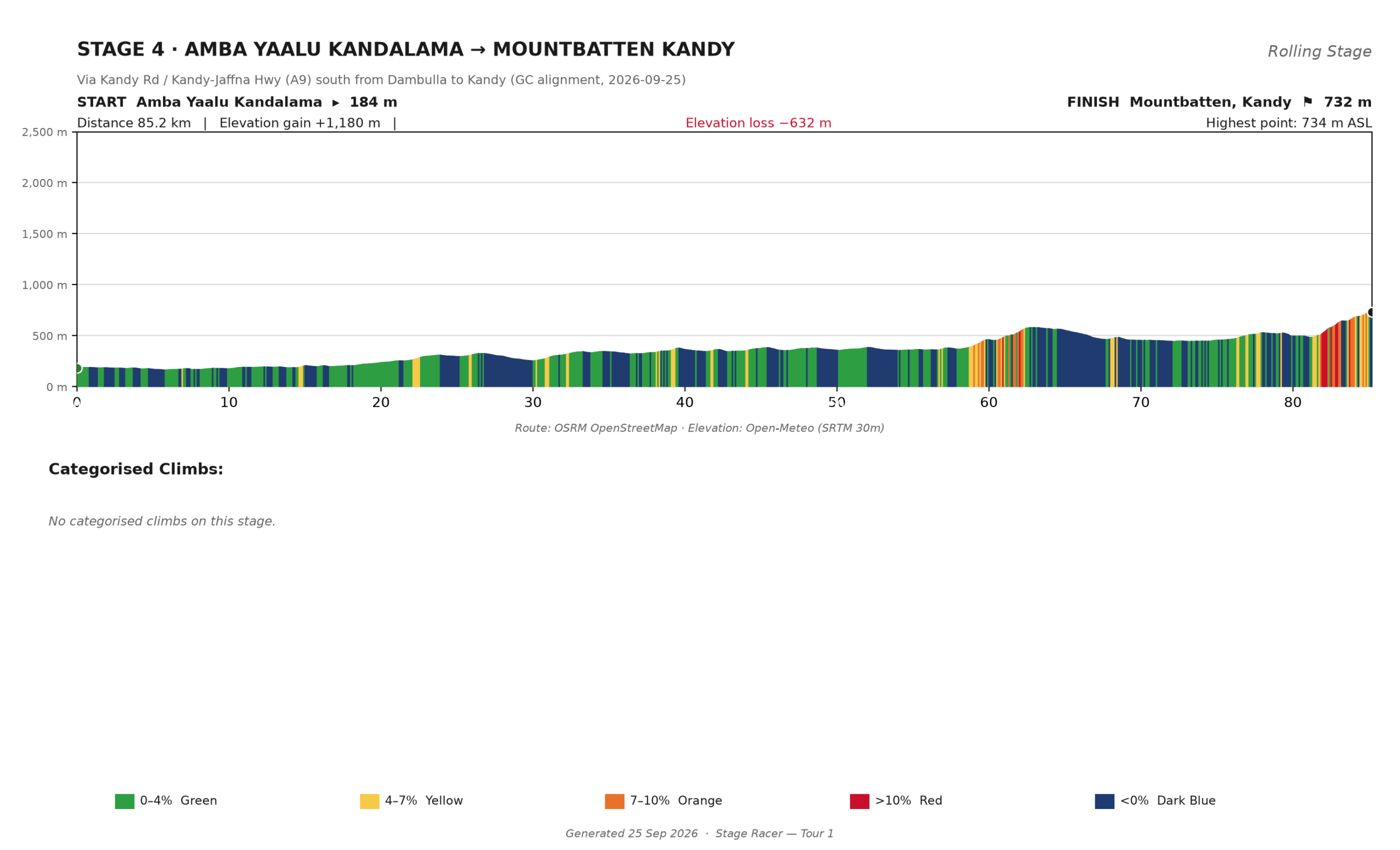
Day 6 · Stage 4: Amba Yaalu Kandalama → Mountbatten Kandy
Via Kandy Rd · A9 south through Dambulla
- 85.2 km
- +1,180 m
- −632 m
- 184 m → 732 m
- ~3 h 20 moving
- No categorised climbs
Home to Kandy via the A9, and the numbers undersell it. The climb out of the dry zone is a sawtooth of two long ramps — a crest near 580 m around km 63, a short valley, then the final 9 km drag back up to Mountbatten at 732 m. Two safe wayside stops: the plateau villages near km 50 and the junction town in that final valley. Ride the first hour like it is easy, because the last hour is not.
At your pace: spin the first 40 km, save the matches, and decide about the finale at the last feed stop.
Afternoon: a loop closed — the same Kandy garden where the tour began, now earned. Laundry, pool, and the Cultural Triangle day-trip menu reopens from here.
 Click to enlarge
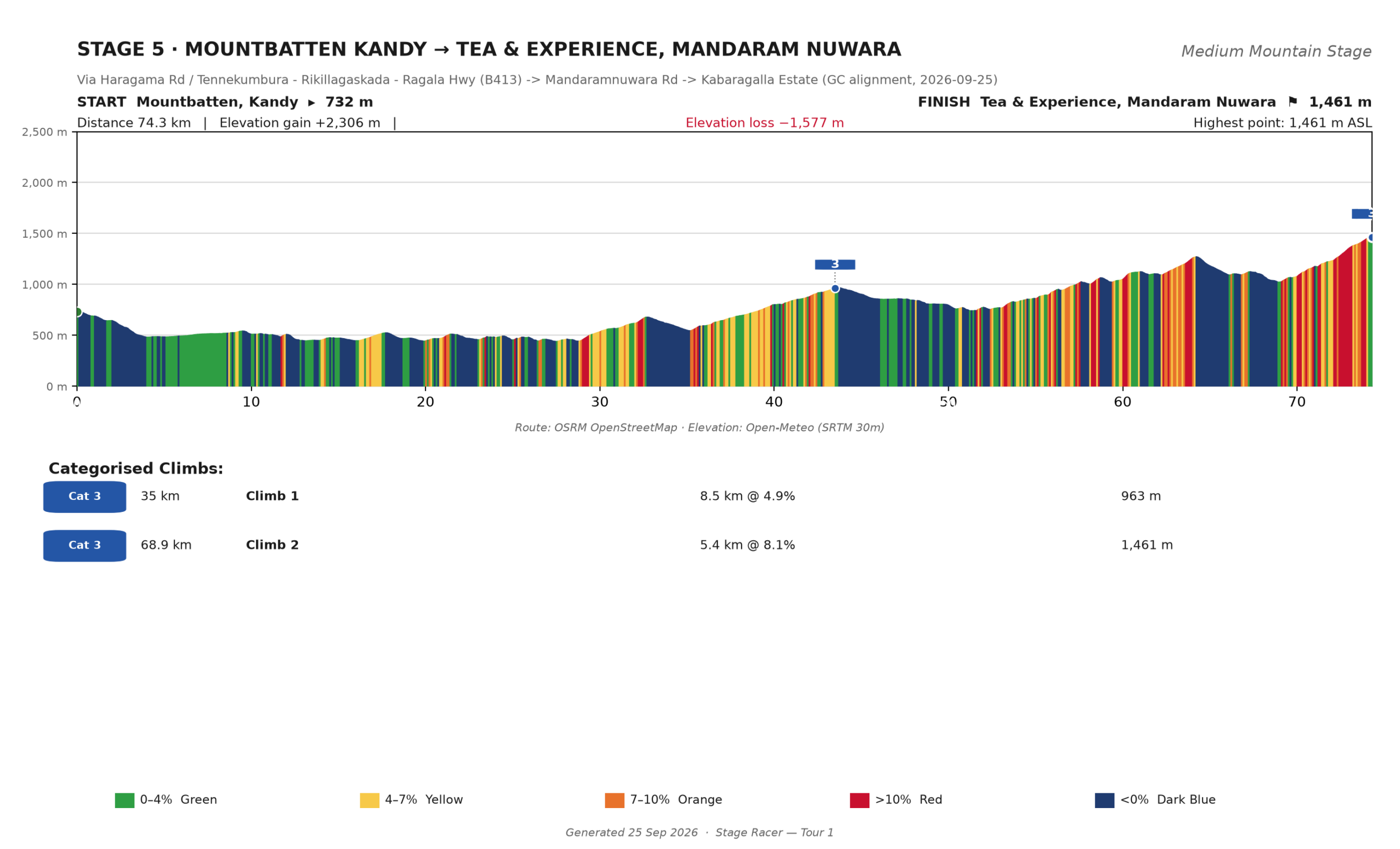
Day 7 · Stage 5: Mountbatten Kandy → Tea & Experience, Mandaram Nuwara
Via Haragama Rd · B413 through Tennekumbura and Rikillagaskada · Kabaragalla Estate
- 74.3 km
- +2,306 m
- −1,577 m
- 732 m → 1,461 m
- ~3 h 25 moving
- 2 categorised climbs (Cat 3)
The tour’s mountain day is its shortest distance: 74 km that climb 2,306 m. It opens with a trap — nearly 300 m down Haragama Rd into the Mahaweli valley, feeling free — and the B413 spends the rest of the morning billing for it. Climb one is an 8.5 km rhythm grind at 4.9% to 963 m. The dip around km 50 is where you eat, because the finale offers nothing: 5.4 km at 8.1%, arriving after 70 km and 1,900 m of earlier climbing, cresting at the hotel gate at 1,461 m. Choose the compact crankset before it, not at km 69.
At your pace: the support vehicle can take the last climb for anyone who wants it. That is the only part of this day we would shorten — everything before it rides at whatever pace you agree. (We are also scouting a B364 alternative corridor for this stage; your version can be built around either.)
Afternoon: you finish where the tea is made — Tea & Experience sits on the working Kabaragalla Estate, with factory visits on the door. Bring the jacket out of the follow van on the last 15 km: estate mist usually arrives by midday.
 Click to enlarge
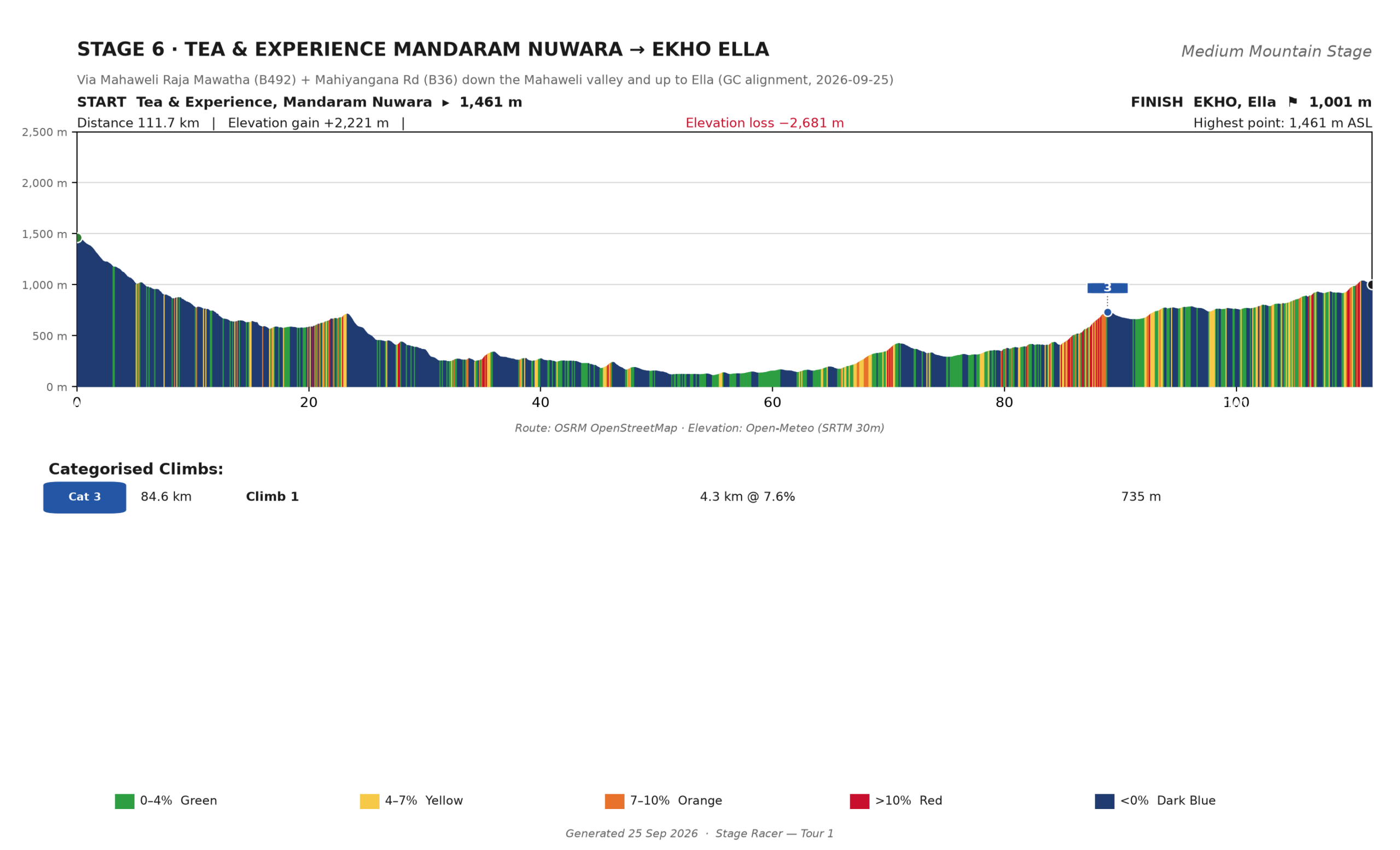
Day 8 · Stage 6: Tea & Experience Mandaram Nuwara → EKHO Ella
Via B492 Mahaweli Raja Mawatha · B36 Mahiyangana Rd · the Uva staircase
- 111.7 km
- +2,221 m
- −2,681 m
- 1,461 m → 1,001 m
- ~4 h 45 moving
- 1 categorised climb (Cat 3)
Two days in one saddle. First the plunge: 1,343 m down from the estate into the Mahaweli gorge on the B492, tea-country chill to open dry-zone heat with a low point near 118 m. Top up before the gorge bottoms out — there is a 30 km gap through the valley townships that punishes optimism. Then the way back up: the B36 staircase toward Ella, repeated short ramps including a 4.3 km Cat 3 at 7.6%, forty-five kilometres of steady climbing that ends at EKHO, 1,001 m. The last 40 km feel like a mountain stage because they are one.
At your pace: the valley floor suits the van’s help and a sheltered rotation; the climb to Ella rewards a steady chase-group rhythm over an early attack.
Afternoon: Ella, back in the hill air. Little Adam’s Peak if the legs want a walk, the Nine Arch Bridge if they do not, Uva tea country all around.
 Click to enlarge
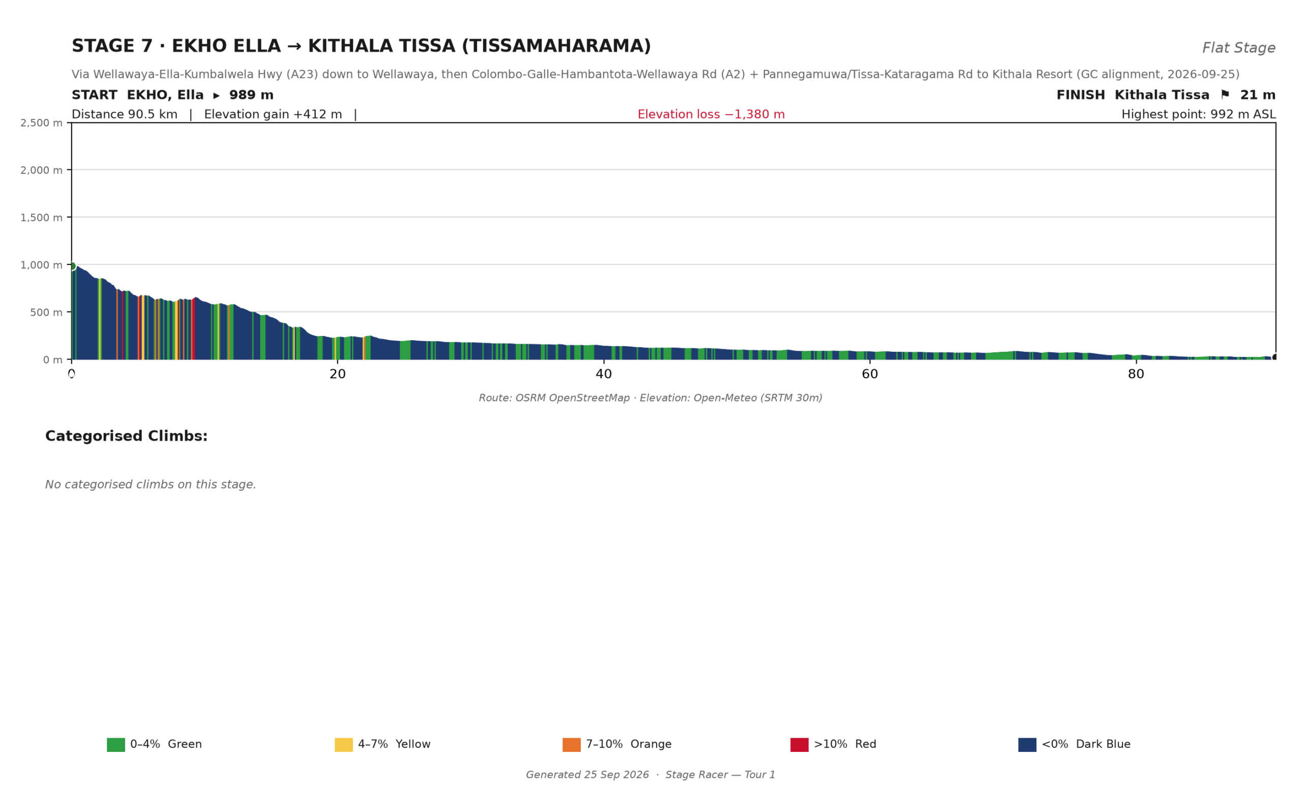
Day 9 · Stage 7: EKHO Ella → Kithala Tissa (Tissamaharama · Yala)
Via A23 Wellawaya–Ella–Kumbalwela Hwy · A2 across the dry-zone plains · Tissa–Kataragama Rd
- 90.5 km
- +412 m
- −1,380 m
- 989 m → 21 m
- ~3 h 15 moving
- No categorised climbs
The Yala gateway stage, and the tour’s honest recovery day: the high point is behind you from the first kilometre as the A23 drops to Wellawaya and the A2 carries you across open plains to near sea level. The resistance today is air, not gradient — the afternoon sea breeze builds a headwind over the last 40 exposed kilometres. Steady cadence, heart rate in zone 1–2, rotate and shelter. Bank the legs: tomorrow is the last stage.
At your pace: nobody owes this day a fast finish. It exists so the finale has riders in it.
Afternoon: Kithala sits on the Kataragama Road with Yala National Park on the doorstep — an afternoon game drive is the obvious move (see Add-Ons).
 Click to enlarge
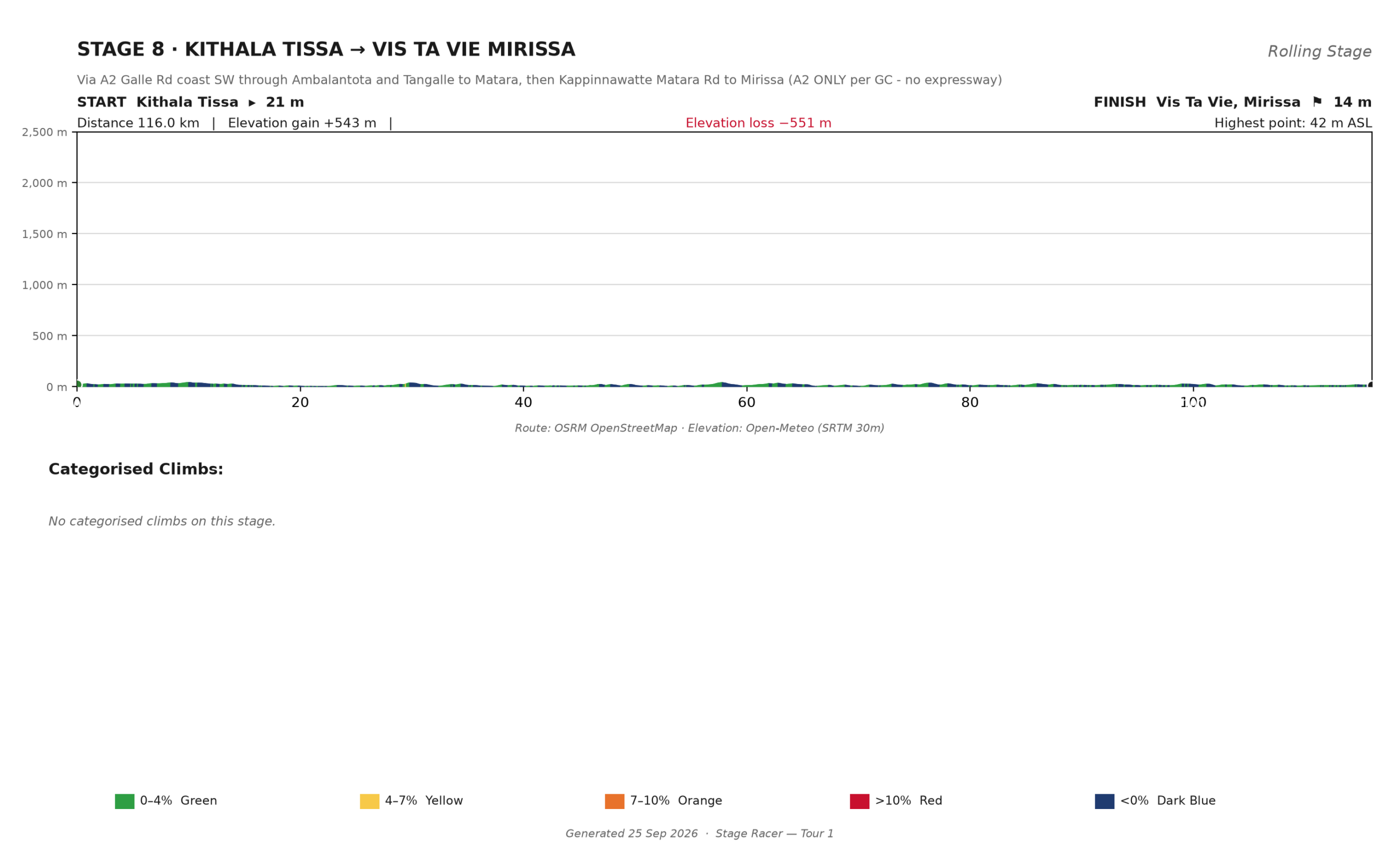
Day 10 · Stage 8: Kithala Tissa → Vista Vie, Mirissa
Via the A2 coast road — Ambalantota · Tangalle · Matara · Kappinnawatte Matara Rd to Mirissa. Surface road all the way: no expressway, ever.
- 116.0 km
- +543 m
- −551 m
- 21 m → 14 m
- ~4 h moving
- Highest point: 42 m
The finale runs the old coast road the whole way. The Southern Expressway parallels this shore and is banned to bicycles, so the tour’s last stage stays on the A2 from Tissamaharama to Mirissa with nothing to dodge but the crossings: the Walawe river near km 25 and the Tangalle and Matara bridges — narrow, sometimes slippery, shared with buses and three-wheelers. Flat, fast, and the only attention the day asks is a steady line and a cool head. Then the south coast and a finish at Vista Vie.
At your pace: flat enough that everyone finishes together, or agrees not to bother.
Afternoon: last bike packed by evening. The beach from here on is the program.
 Click to enlarge
Day 11 · Mirissa — a full day of sea
No stage. No roll-out time.
Mirissa headland, the beach, the swim, a long lunch, and whatever version of doing nothing the body asks for after nine days on the bike. An easy coastal out-and-back is possible for anyone genuinely unable to sit still, and a whale-watching morning can be booked (see Add-Ons). If this day feels short, scroll down — it is the one most riders extend.
Day 12 · Departure
Morning beach · late check-out · chauffeured transfer to Colombo.
Swim first, pack after. Your chauffeur runs the transfer to Colombo for the flight home, bikes boxed and labelled. If one night of sea felt long and two would have felt right, that conversation belongs in the Add-Ons below — or in your inquiry, which is where all of this gets tailored anyway.
Add-Ons: days that are not stages
Every Stage Racer tour bolts on extra days at both ends and inside the itinerary. The published 12 days stay the headline; the rest is yours.
Before the tour. Long-haul flights arrive in a different time zone. Add a night or three in Kandy before roll-out — sleep properly, build the bike, and let the acclimatisation ride meet fresh legs.
Inside the tour. Any stage morning can become a rest day: pool, spa, a short guided loop, culture in the afternoon. The natural slots are the day after the long opener into Gal Oya, and a second night at Mountbatten Kandy when the route loops back through the Cultural Triangle. A block with a rest day in it is better training than a block you ride tired.
After the tour. This blueprint ends with one full beach day. Two extra nights at Mirissa make it two proper days — a slower finish, a whale boat, the Galle Fort walk done at the speed you actually want. Airport transfers are arranged around whatever you add.
Experiences between the handlebars: Gal Oya boat safari · Sigiriya Lion Rock · Dambulla cave temple · Temple of the Tooth · tea-factory visits at Mandaram Nuwara and Ella · Little Adam’s Peak and the Nine Arch Bridge · a Yala game drive · whale watching at Mirissa · the Galle–Unawatuna coastal ride · golf at Victoria.
Add-ons are quoted per person as line items on the same inquiry, at the same Thema Collection hotels, with transfers re-timed by Connaissance de Ceylan around the changed itinerary. You see the price of every extra day before you say yes. The full menu lives on the Add-On Experiences page.