
Sample Tour · Published blueprint · Every booking tailored
Sample Tours. Tailored Trips. Your Pace. This is our third published blueprint: real roads, verified numbers, actual hotels. No departure we run is ever a copy of this page. Your Stage Racer tour is tailored to your individual requirements — every stage ridden at your pace.
The distances, climbs and profiles on this page come from our own pipeline: road routing through the exact towns and roads we scout, elevation sampled from terrain data at roughly 100 m spacing. Every stage is a day you own — ride the full profile, take the shortened route, or let the support vehicle carry you over any section on the day.
A rouleur is the rider who crosses flat and rolling ground fast, who never suffers on the climbs because the climbs never arrive. That is this tour: eight riding days, three coasts, tank-country plains, and a highest point of two hundred and eighty-one metres. There is no mountain in it, and no afternoon on the bike.
- 11 days · 10 nights
- 8 riding days
- 812 km
- +3,985 m climbing
- High point 281 m
- Longest day 141 km
- Zero categorised climbs
- West · east · south coasts
Day 1 · Arrive Colombo → Puttalam coast
No stage profile — no legs required today.
You land at Colombo (CMB or BIA) and your chauffeur takes you north to Bethany 101 on the Puttalam coast, in time for a mid-morning arrival. Bikes are unboxed and built this afternoon; if you are renting instead of flying with boxes, the fit happens here too. The rest of the day is the pool, at whatever speed jet lag allows.
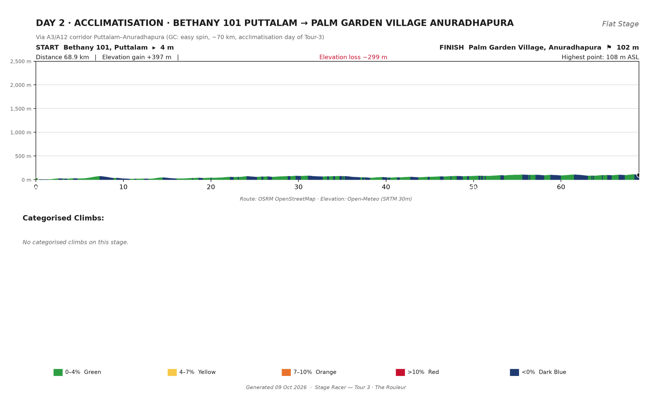
Day 2 · Acclimatisation ride: Bethany 101 → Palm Garden Village, Anuradhapura
Via the A12 corridor Puttalam–Anuradhapura
- 68.9 km
- +397 m
- −299 m
- 4 m → 102 m
- ~2 h 30 moving
- No categorised climbs
A 07:00 roll-out and the gentlest way to open the legs: sixty-nine kilometres from sea level to the dry-zone plateau, with the day’s entire climbing budget spent on one long, lazy ramp. Nothing pinned, nothing memorised.
Afternoon: the reason this stop exists. The Ruwanwelisaya stupa, raised in 140 B.C., is eight kilometres from the hotel; the Jaya Sri Maha Bodhi — a cutting of the tree under which the Buddha attained enlightenment, planted over twenty-three centuries ago — is ten. Both by van. The legs stay dry.
 Click to enlarge
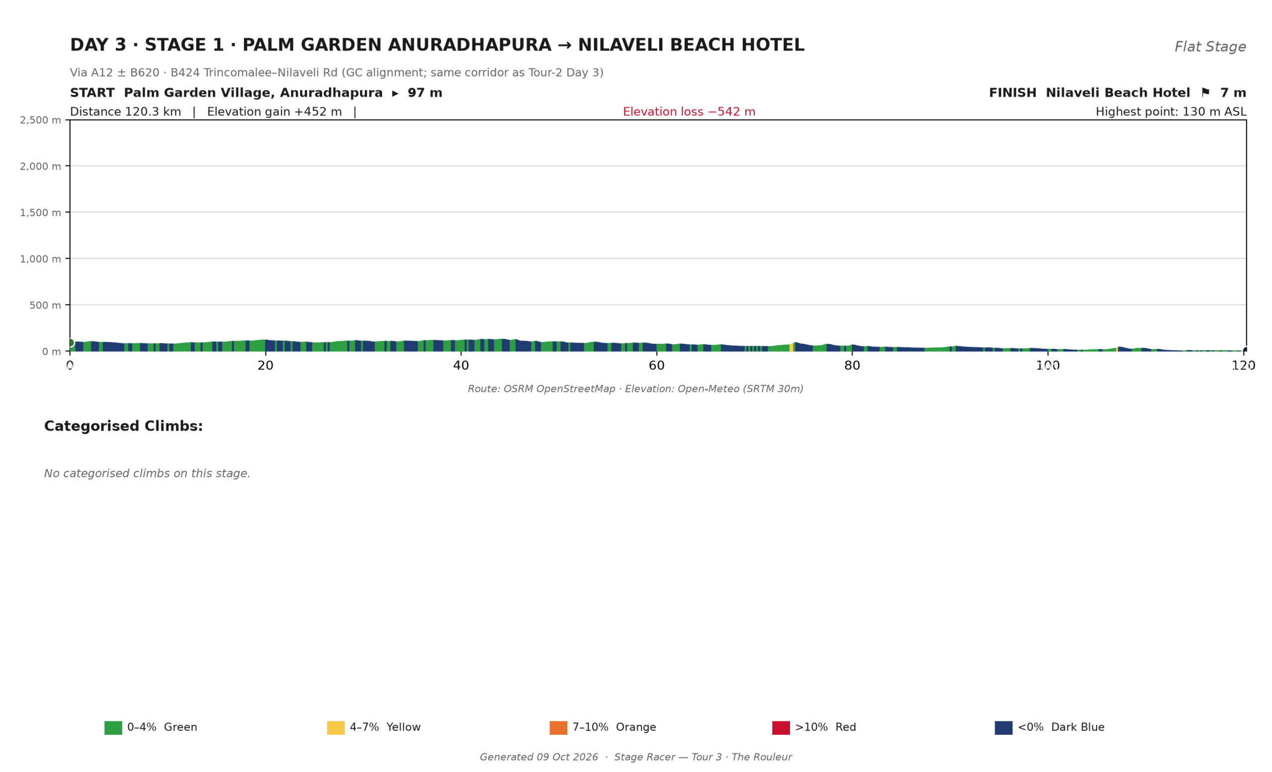
Day 3 · Stage 1: Anuradhapura → Nilaveli Beach Hotel
Via A12 · B620 · B424 Trincomalee–Nilaveli Rd
- 120.3 km
- +452 m
- −542 m
- 97 m → 7 m
- ~4 h 15 moving
- No categorised climbs
North-east across the old dry zone, the road mostly falling toward the sea. The first half runs flat and fast through tank country; the climbing hides in the rollers before Trincomalee, and after that it is a long release down the coast road to Nilaveli. A 06:00 start puts you on the beach by mid-morning.
At your pace: a conversation day. The van shadows the whole route, and the only clock that matters is the one that says stop before the heat.
Afternoon: exactly what it looks like from the terrace — sand, sea, pool, shade.
 Click to enlarge
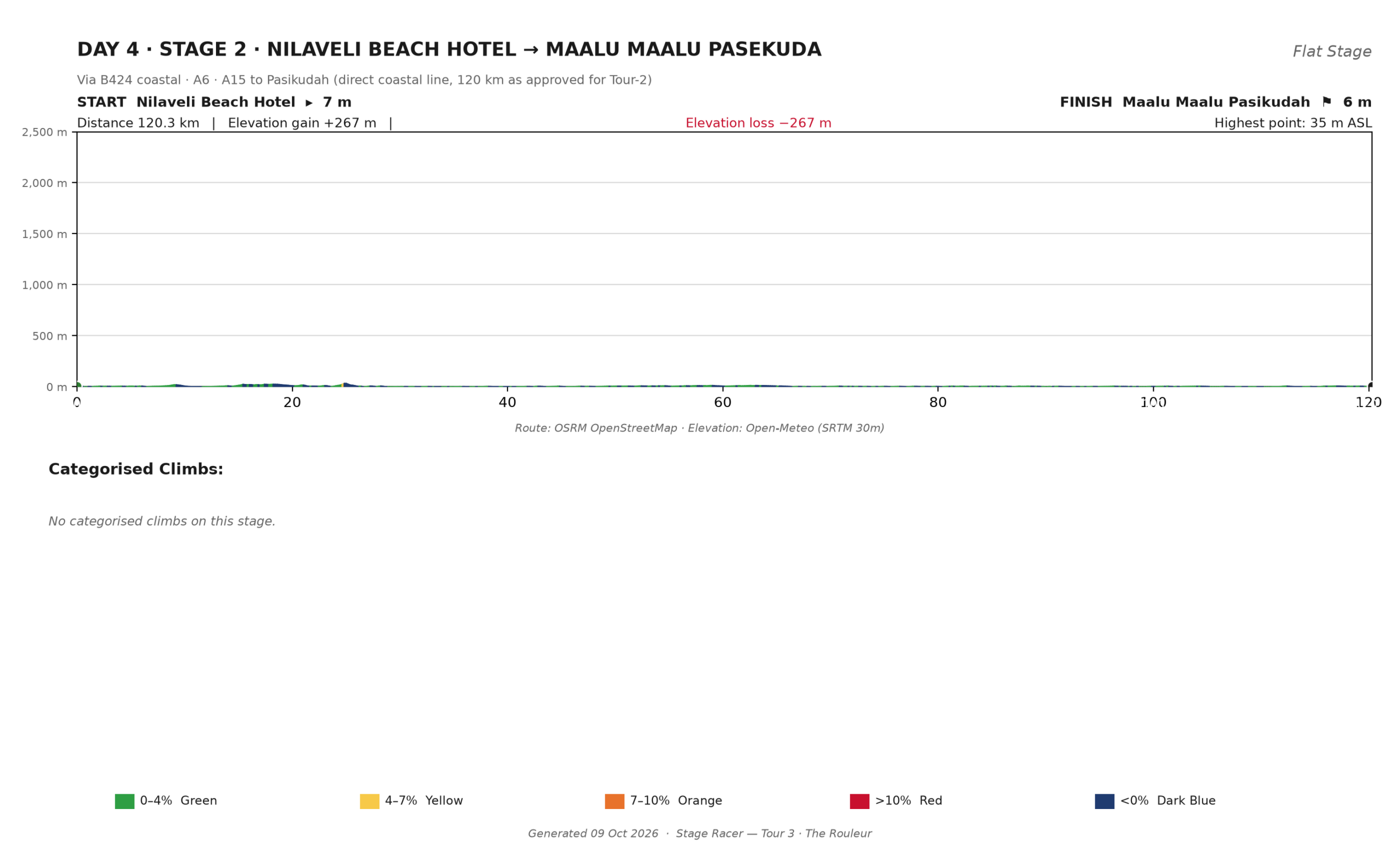
Day 4 · Stage 2: Nilaveli → Maalu Maalu, Pasikudah
Via B424 coastal road · A15 · A6 south of Trincomalee
- 120.3 km
- +267 m
- −267 m
- 7 m → 6 m
- ~4 h 10 moving
- Highest point: 36 m
The flattest day we have ever published, on either tour: one hundred and twenty kilometres that never rise above thirty-six metres. Around the head of Trincomalee harbour and then south on the east-coast plain, with the wind as your only climbing. The trick today is boredom management — steady power, rotation at the front, shelter in the bunch — because the road will not make the decisions for you.
At your pace: a rhythm day with a beach at the end of it. Nobody is dropped on a road with no climbs.
Afternoon: Pasikudah’s reef-sheltered shallows, warm by late morning. Arrive around eleven, in the water before twelve.
 Click to enlarge
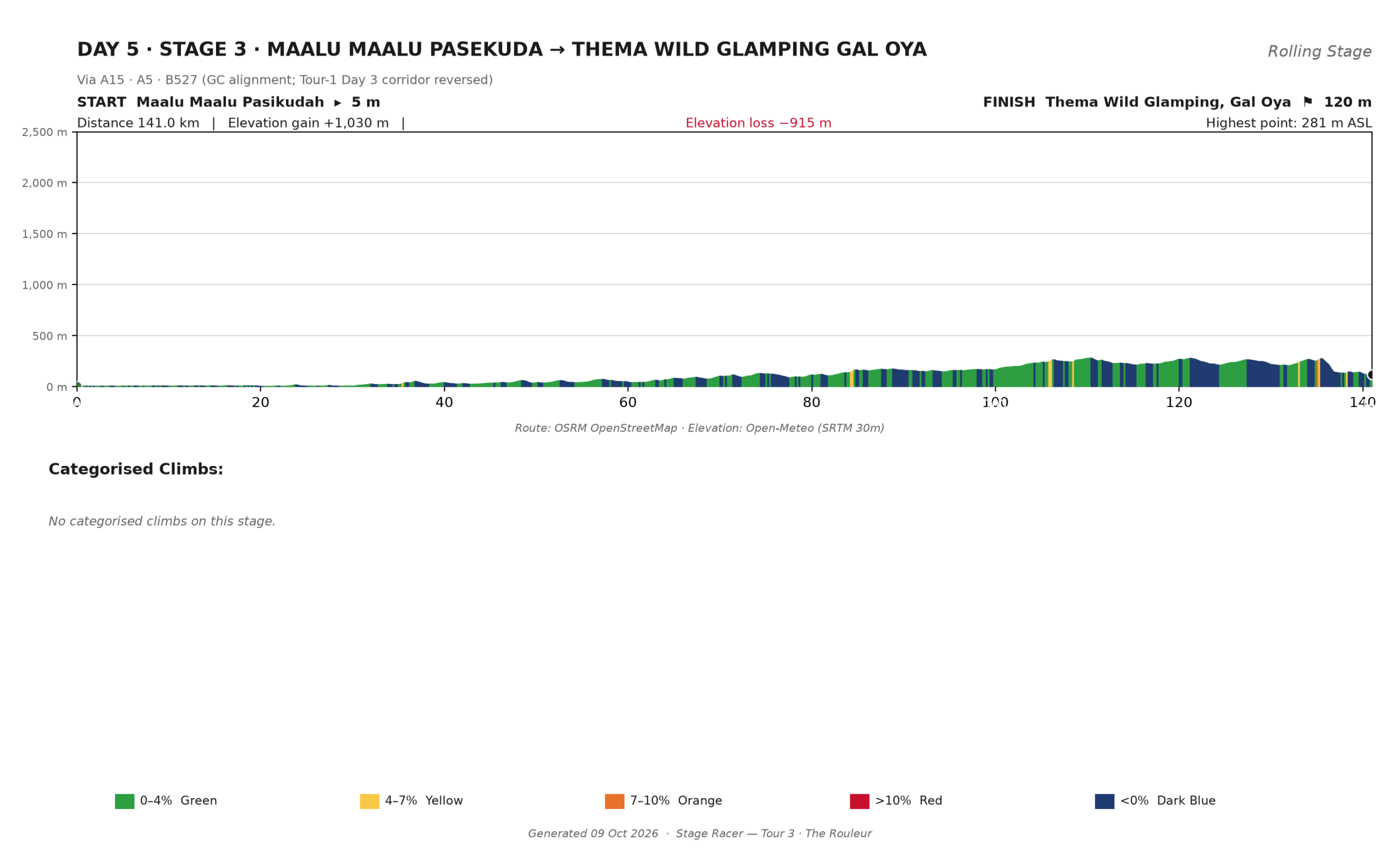
Day 5 · Stage 3: Maalu Maalu, Pasikudah → Thema Wild Glamping, Gal Oya
Via A15 inland · A5 through the Ampara plain · B527 to the lake
- 141.0 km
- +1,030 m
- −915 m
- 5 m → 120 m
- ~5 h 05 moving
- No categorised climbs
The longest day of any Stage Racer tour, and the only one that turns its back on the sea. Inland through the Ampara rice plain on Sri Lanka’s longest road, then the B527 rising in long shallow steps to the Gal Oya valley. A rouleur’s day in the purest sense: one hundred and forty kilometres, a thousand metres of climbing, and not a single wall to stand up on. Empty the tank at the front while it is flat; be in the right half of the group when the rollers steepen past Ampara.
At your pace: an 06:00 roll-out is the whole plan on a day of this reach. The support vehicle carries bottles, and the lake arrives long before the heat does.
Afternoon: Wild Glamping sits on the shore in the middle of elephant country. Herds are regulars around the water in the late afternoon, from a respectful distance and without anyone crowding them. The camp’s boat safari on the lake — the only way to see its shoreline herds properly — can be arranged before you fly home.
 Click to enlarge
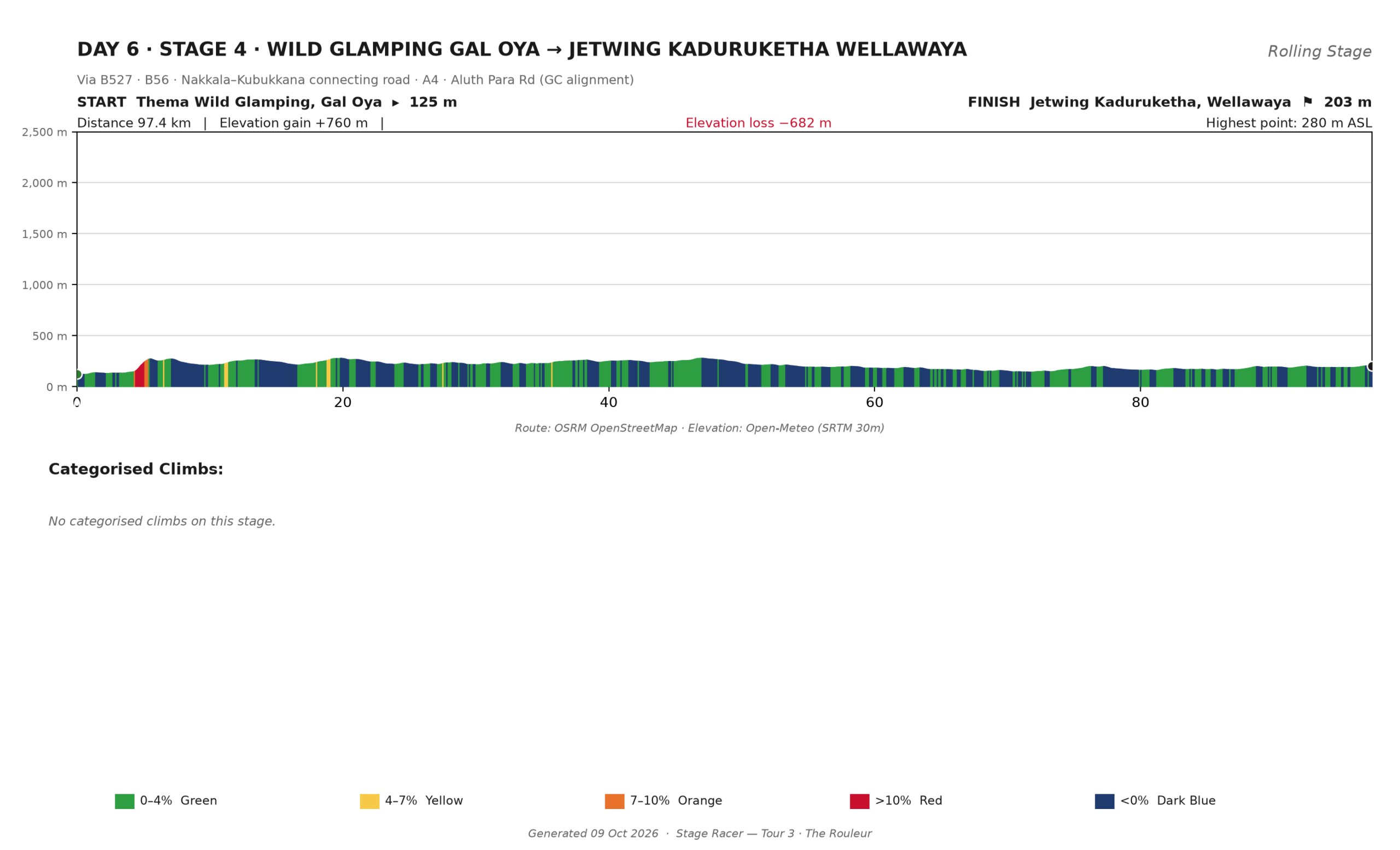
Day 6 · Stage 4: Wild Glamping Gal Oya → Jetwing Kaduruketha, Wellawaya
Via B527 · B56 · Nakkala–Kubukkana connect · A4 · Aluth Para Road
- 97.4 km
- +760 m
- −682 m
- 125 m → 203 m
- ~3 h 30 moving
- No categorised climbs
South out of the lake camp through buffer forest and satellite tanks, over the shoulder of the valley and down toward Wellawaya on the A4. A day of short, steepish gradients rather than any one big hill — the profile reads like the teeth of a saw laid sideways.
At your pace: spin the little climbs in the low gear you saved, and let the van collect anyone who wants the view instead of the effort.
Afternoon: Kaduruketha is a Jetwing house set in working paddy at the edge of the Uva plain — pool, verandah, and birdsong that has no opinion about bicycles.
 Click to enlarge
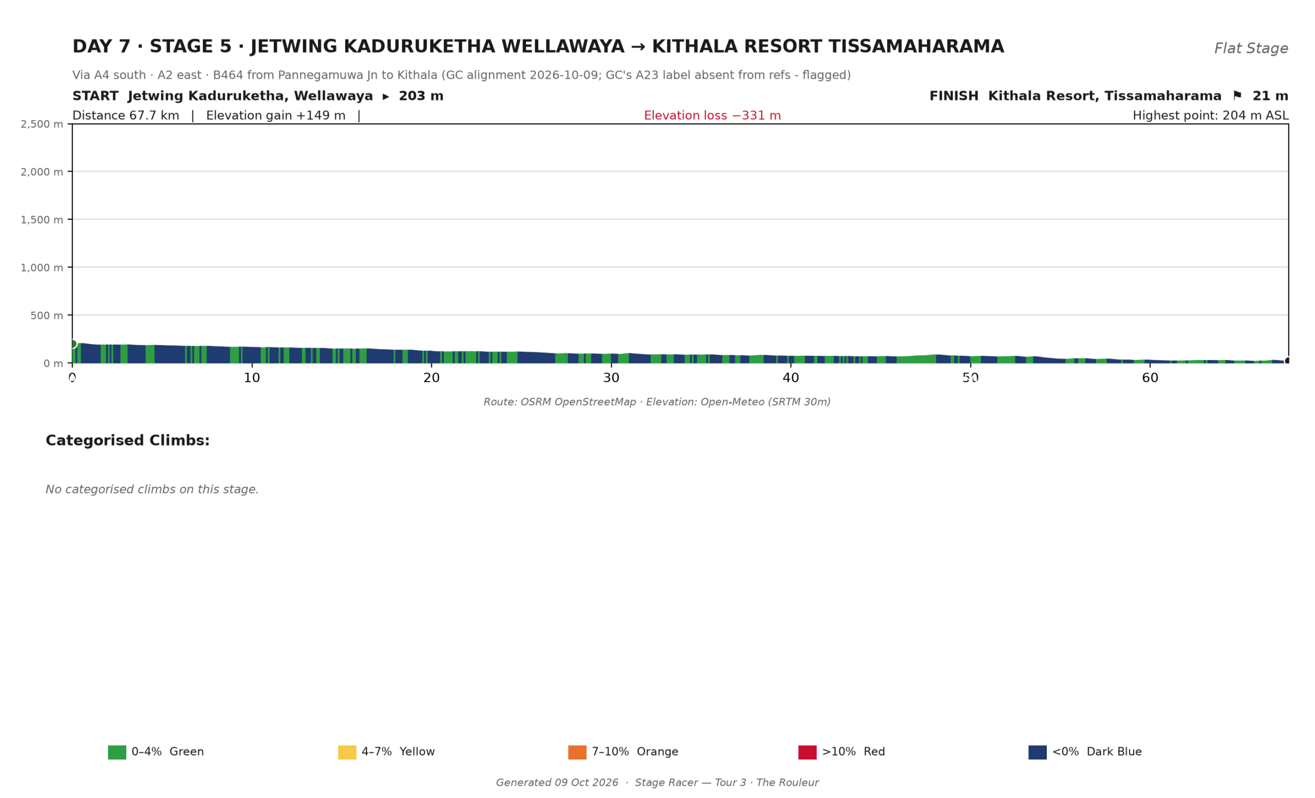
Day 7 · Stage 5: Jetwing Kaduruketha → Kithala Resort, Tissamaharama
Via A4 south · A2 east · B464 from Pannegamuwa Junction
- 67.7 km
- +149 m
- −331 m
- 203 m → 21 m
- ~2 h 20 moving
- No categorised climbs
The short day before the big one: sixty-eight easy kilometres falling from the Uva plain to the wet-zone lowlands, most of it on the smooth stretches of the A2 toward Pannegamuwa Junction. Legs down, brakes off, arrive mid-morning.
At your pace: the whole point of today is what happens after lunch.
Afternoon: Tissamaharama is Yala’s front door — Kithala sits on the same road as the park. A game drive in the late afternoon takes the leopards, sloth bears and elephants while the light goes gold; you are back at the resort for sundowners on the lake terrace.
 Click to enlarge
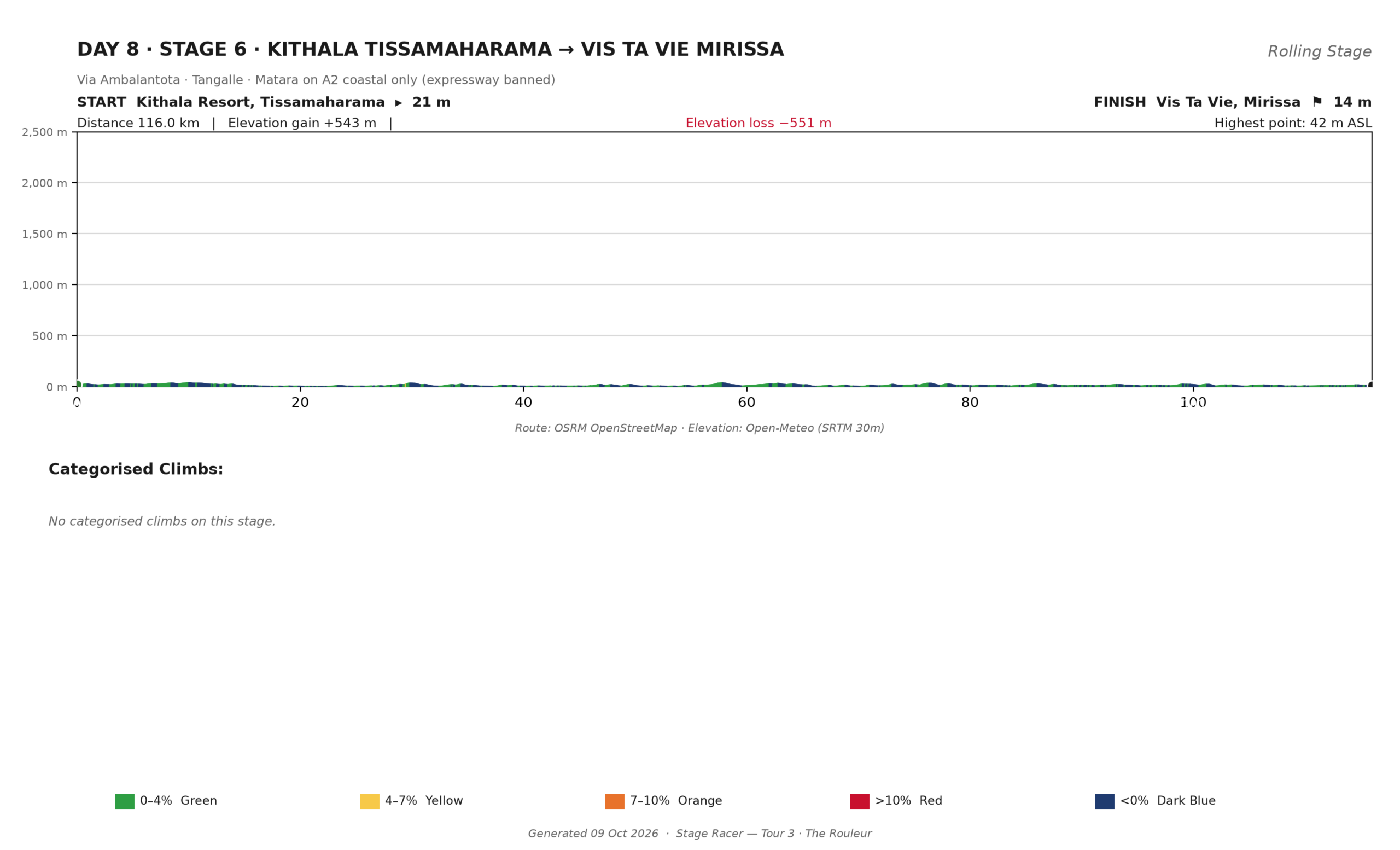
Day 8 · Stage 6: Kithala Tissamaharama → Vis Ta Vie, Mirissa
Via Ambalantota · Tangalle · Matara on the A2 — coast road only
- 116.0 km
- +543 m
- −551 m
- 21 m → 14 m
- ~4 h 15 moving
- No categorised climbs
The finale: the southern coast from Tissamaharama to Mirissa on the old A2, and not a metre of expressway. Rolling, never steep, past Ambalantota’s temple, through Tangalle’s string of bays, over the Dutch-era bridge at Matara. Map apps will offer you a faster number via the Southern Expressway; that number is illegal on a bicycle and we do not use it.
At your pace: tailwind most mornings, ocean on the left, Mirissa by lunch.
Afternoon: bikes in bags tonight. Beach, and a long dinner with a cold carafe of something.
 Click to enlarge
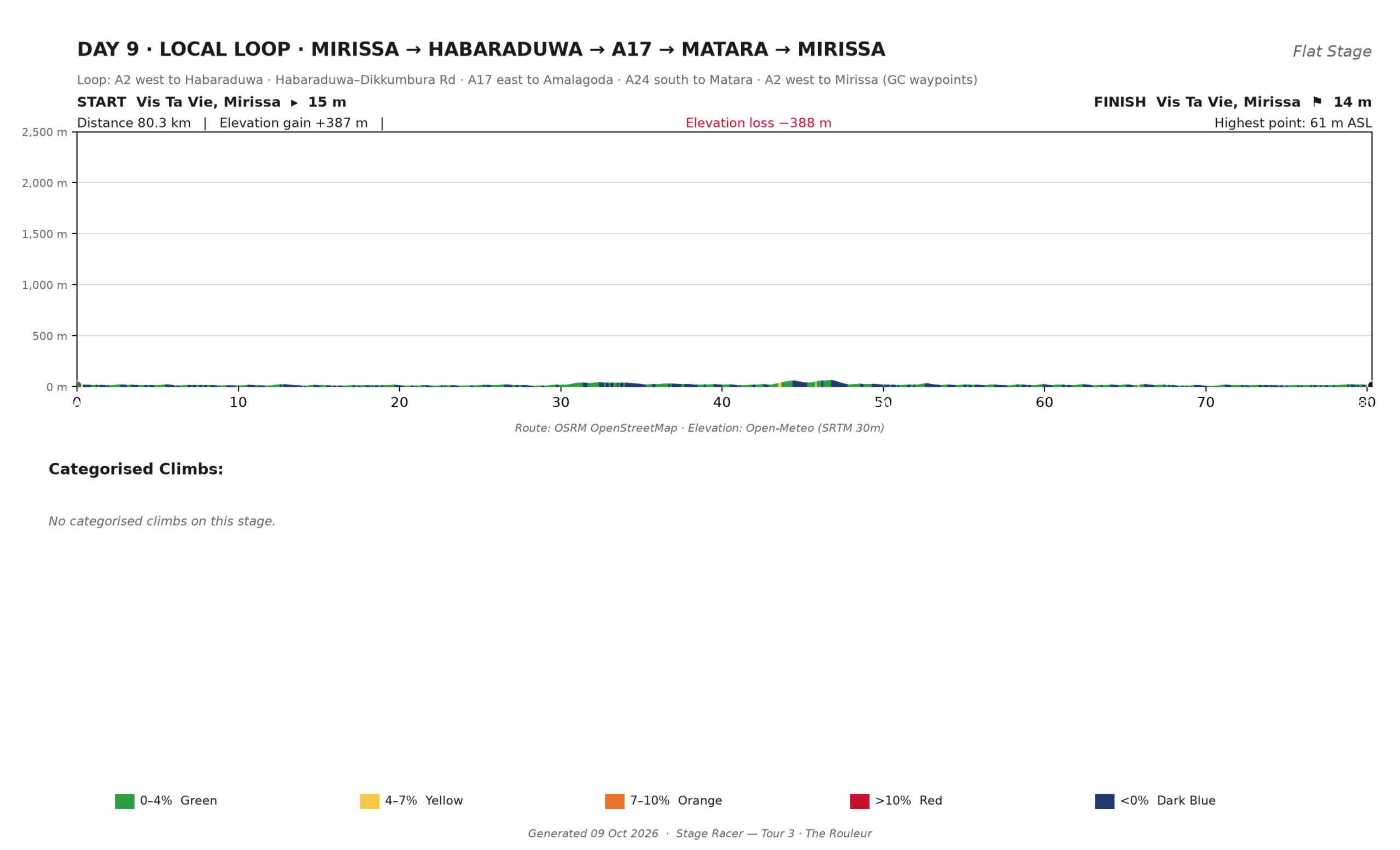
Day 9 · The local loop: Mirissa → Habaraduwa → A17 → Matara → Mirissa
A2 west · Habaraduwa–Dikkumbura Rd · A17 east to Amalagoda · A24 south to Matara · A2 back
- 80.3 km
- +387 m
- −388 m
- 15 m → 14 m
- ~2 h 45 moving
- No categorised climbs
One more ride on the day after the finale, and the only day this tour goes in a circle. West along the coast road past Unawatuna to Habaraduwa, inland on a quiet B-road to the A17, east along it to Amalagoda, then down the A24 through Matara and home along the shore on the A2. Rolling jungle country, fishing villages, and one long cinnamon-scented afternoon if you ride it slowly.
At your pace: entirely optional in practice — plenty of guests ride half and swim the rest. The road brings you back to the same beach either way.
 Click to enlarge
Day 10 · Mirissa — a full day of sea
No stage. No roll-out time.
A day of nothing: the beach, the pool, a long lunch facing the water, and whatever version of stillness the body asks for after nine days in the saddle. If this day feels short, scroll down — it is the one most riders extend.
Day 11 · Departure
Morning beach · check-out · chauffeured transfer to the airport.
Swim first, pack after. The transfer runs to Colombo with the bikes boxed and labelled, the Indian Ocean on one side and an expressway you are allowed to use on the other. If one night of sea felt long and two would have felt right, that conversation belongs in the Add-Ons below — or in your inquiry, which is where all of this gets tailored anyway.
Add-Ons: days that are not stages
Every Stage Racer tour bolts on extra days at both ends and inside the itinerary. The published 11 days stay the headline; the rest is yours.
Before the tour. Long-haul flights arrive in a different time zone. Add a night or three at Bethany 101 on the Puttalam coast before roll-out — sleep properly, build the bike, and let the acclimatisation ride meet fresh legs.
Inside the tour. Any stage morning can become a rest day: pool, spa, a short guided loop, culture in the afternoon. The natural slots are a second morning at Nilaveli, when the east coast is at its best, and a second night at Wild Glamping — one lake evening is never enough for people who crossed an ocean to see elephants at the waterline. A block with a rest day in it is better training than a block you ride tired.
After the tour. The Rouleur ends with a day of sea that can be a week. Extra nights at Vis Ta Vie make it two, three, seven, as many as you like — the slower version of the south coast, done at the speed you actually want. Airport transfers are arranged around whatever you add.
Experiences between the handlebars: the sacred Anuradhapura cluster · Pigeon Island snorkelling off Nilaveli · Gal Oya’s boat safari · the Yala game drive on Day 7 · whale-watching out of Mirissa in season · the Maththala lagoon, twenty minutes from Kithala.
Add-ons are quoted per person as line items on the same inquiry, with transfers and support re-timed around the changed itinerary. You see the price of every extra day before you say yes. The full menu lives on the Add-On Experiences page.